
Two golf courses, a tennis club and 115 hectares at Potters Crouch are among 115 sites offered for the next St Albans Local Plan. Your first say: April 2027.
Landowners and developers have put forward 115 sites for building in the next St Albans Local Plan, less than two months after the current one was adopted. They include two golf courses, a tennis club, a station car park and 115 hectares of farmland at Potters Crouch.
St Albans City and District Council has published the full list of submissions on its Call for Sites 2026 page. Nothing on it has been chosen. It is a list of land that its owners or promoters would like the council to consider.
Why there is a new plan already
The Local Plan adopted on 9 September runs to March 2041. The government still required the council to start the next one this year. A report to the Planning Policy and Climate Committee on 20 October says St Albans is one of 39 councils that had to publish an early self-assessment by 31 October. These are councils that submitted plans by March 2025 meeting less than 80% of their housing need.
The report warns that missing the deadline “would almost certainly result in Government intervention”, with the council paying the costs. It notes the government has already intervened in the Three Rivers plan and nine others.
How many sites, and from whom
The council sent the invitation on 17 July to 2,792 people and organisations, according to the same report. Submissions closed at 5pm on 18 September. It received 115.
The council marks seven of them as duplicates or subsets of other entries. Five entries, one of them flagged as a duplicate, are for the same 6.6-hectare field opposite Common Lane at Kimpton Bottom, near Harpenden. Each was sent by an individual plot owner.
Most sites ask for housing. Some ask for other things:
- a data centre or warehousing on 83.78 hectares north of Harper Lane, near Radlett, from Tarmac, of which about 20 hectares would be built on
- roadside services and logistics beside the A414 at Tyttenhanger and Colney Heath, also from Tarmac, including a petrol or EV charging station, a hotel and lorry parking
- industrial units at Smallford Works and Appspond Lane
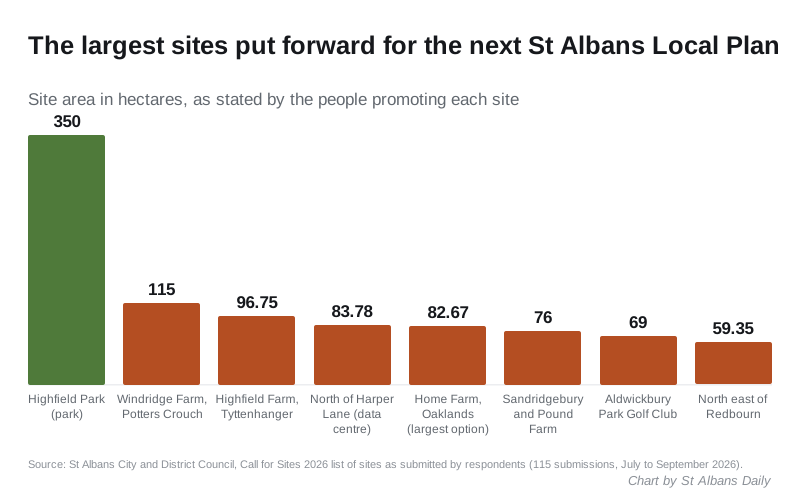
- a 350-hectare park from the Highfield Park Trust, which wants to create a “Green Lung” that would “buffer St. Albans from expected development to the south”
The biggest sites
| Site | Promoter | Area | Proposed |
|---|---|---|---|
| Windridge Farm, Potters Crouch | Catesby Estates and CP Holdings | 115 ha | Homes, open space, possible primary school |
| Highfield Farm, Tyttenhanger | Hertfordshire County Council | 96.75 ha | Mixed use including homes |
| Home Farm, between Highfield Lane and Colney Heath Lane | Oaklands College | 21.43 to 82.67 ha | Homes |
| Sandridgebury Farm and Pound Farm | Lightwood Strategic | 76 ha | A “strategic extension to North St Albans” |
| Aldwickbury Park Golf Club, Harpenden | Burhill Group | 69 ha | Homes, with golf kept |
| North east of Redbourn | Lands Improvement Holdings | 59.35 ha | Homes and a primary school |
| Noke Lane, Chiswell Green | Clowes Developments | 56.5 ha | Employment, homes, community, sport |
| Batchwood Golf Course | A private individual | 54.83 ha | Homes, with new sports facilities |
The areas are the promoters’ own figures. Most submissions give no number of homes.
Burhill Group’s entry for Aldwickbury Park lists a strategic site of “approximately 550 homes” and medium sites of “approximately 200 homes”, while keeping golf and leisure on the land. The Batchwood entry proposes housing “with additional sports facilities to compensate for loss of golf course”.
None of the sites in the Colney Heath and Tyttenhanger area gives a number of homes in the council’s list.
Smaller sites people will recognise
- Victoria Street car park at St Albans City station: flats on the upper floors, with shops or services such as a dentist below. The entry gives no site area.
- Salisbury Avenue Tennis Club: 0.25 hectares for new housing.
- Former Butterfly World, Miriam Lane: 11 hectares for commercial use or housing.
- Network Rail land north of St Albans Abbey station (0.42 hectares) and beside Park Street station (0.18 hectares), both for housing.
- Napsbury: 8.4 hectares north of Napsbury Park for homes, older people’s housing, a doctors’ surgery and “potential for new railway station”.
- Three Church of England sites from the St Albans Diocesan Board of Finance: the Holy Trinity vicarage and glebe land at Frogmore, land beside the London Colney allotments, and land off Marford Road in Wheathampstead, where the allotments would move.
- Shottfield Close, Sandridge, which councillors already resolved to approve in September, subject to a legal agreement.
What the council has said about housing numbers
At Full Council on 14 October, councillors passed a motion opposing the scale of what is expected next. The printed minutes record the vote as 36 for, 4 against and 2 abstentions.
The motion says the adopted plan already provides for more than 15,000 homes over 15 years, a 25% increase in the district’s housing. It says a further 9,000 homes in the next plan “is not deliverable in a genuinely sustainable way”. It points to:
- the Luton Airport expansion just north of the district
- the rail freight terminal being built near the southern boundary, and its effect on the A414
- a forecast that Thameslink will be full within five years
- the Bowman’s Cross scheme in neighbouring Hertsmere
The council instructed its Leader to write to the housing minister. The minutes do not say whether the letter has been sent, and the council has not published it.
What happens next
The council’s timetable for the next plan was confirmed on 26 October:
| Stage | Date |
|---|---|
| Plan content and evidence consultation | 12 April to 25 May 2027 |
| Proposed plan consultation | 17 April to 13 June 2028 |
| Sent to the government for examination | 30 October 2028 |
| Adoption | 27 April 2029 |
Every site will now be assessed under a draft site selection method noted by the committee on 20 October. It builds on the method the inspectors accepted for the current plan.
What it means for you
- Nothing on this list has permission or an allocation. It shows which land is on offer, not which land will be chosen.
- Check the list for land near you. Search the PDF for your road, village or postcode. Sites near Harpenden, Wheathampstead, Redbourn, Colney Heath, Bricket Wood, Chiswell Green and How Wood appear several times.
- Your first formal say is in spring 2027. The consultation from 12 April to 25 May 2027 is the first stage where residents can comment on what the plan should contain.
- Some green belt sites can still win permission before any plan, as Shottfield Close did. Our St Albans planning news page tracks those decisions.
Have your say